
Pictures came out when the U.S. trade office announced its new agreement with India. Most people thought talk would center on taxes, business openings, and money impacts. Yet one detail shifted everything. The image displayed Jammu and Kashmir – all of it, including areas held by Pakistan and China – drawn inside India’s boundaries. Arunachal Pradesh appeared just as clearly marked, shown whole, with no notes questioning ownership. Silence surrounded these choices, but their weight spread fast. Lines on a map spoke louder than words in the release.
Maps in South Asia tend to stir debate, given how tightly boundaries tie into politics and national identity. This one drew attention fast – not since India’s stance on territory is any surprise – but because America usually treads carefully when showing contested areas. What stood out was the lack of hesitation here, sparking curiosity: Why now? What message might this send? Around the same time, economic ties between Delhi and Washington began shifting, adding weight to every detail shown. A quiet change in lines on paper suddenly felt loaded, interpreted through the lens of bigger shifts unfolding behind closed doors.
What made the map stand out comes clearer once you look at the past. South Asia has seen U.S. efforts stretch over years – steady moves meant to keep things level. Closer bonds with India grew, yet links with Pakistan still mattered just as much. China’s rising tension played into those choices too. How borders appear on American maps often echoed that caution. Jammu and Kashmir? Often marked with breaks, speckled boundaries, or small print calling it contested. Areas like PoK and Aksai Chin rarely showed up without some hint of dispute nearby.
With things unfolding this way, the USTR map stood out by breaking past patterns. Not once did it recognize Pakistan’s stance on PoK, just as it skipped backing China’s position on Aksai Chin. Matching India’s official map became its clear path. Without any statement attached, the image still gained weight simply by being shared through a recognized US government outlet – something independent versions never achieve.
Still, reading too much into the map’s purpose might miss the point. Every image from a government source does not come from a top-level strategic choice. Groups focused on commerce, unlike embassies or state departments, tend to pull from standard maps or accept how local authorities draw borders. Chances are high this one came from existing Indian sources or common global data, never checked for political meaning. That fact makes it harder to claim the graphic signals a real change in American stance.
Still, calling the map just a mistake misses how politics actually work. Around Kashmir and the India–China border, U.S. officials know tensions run high. Previous moves show they often sidestep disputes when possible. So even if no message was meant, letting the image stay public after review hints at quiet approval. What gets accepted in government circles sometimes speaks louder than decisions themselves.
Since gaining independence, India has held the same view about Jammu and Kashmir, PoK, and Aksai Chin. The claim rests on a clear belief: these areas belong fully to India, regardless of outside approval. Legal status matters more than global opinion in New Delhi’s eyes. Maps drawn abroad may show the territory differently – but their accuracy isn’t what makes India’s case real. Recognition doesn’t create truth here; silence just prevents dispute. Still, when influential countries depict borders one way or another, symbolism seeps into politics. Past involvement from nations at large turned local disputes into wider diplomatic themes. Now, even quiet cartographic choices speak volumes.
What stands out grows clearer once you look at what Pakistan has done lately. Back in 2020, a new political map came from them, laying claim to Jammu and Kashmir, chunks of Ladakh, plus places like Junagadh and Sir Creek down in Gujarat. New Delhi shot it down fast, labeling the move baseless under law and driven by politics. Most nations stayed silent on the matter, yet Washington made no mention of support either, holding firm to its stance of staying neutral in official statements. Still, the USTR version of the world stays clear of backing that vision entirely – leaving Islamabad’s mapping effort off the page.
Lately, attention’s grown because of Pakistan reaching out diplomatically in Washington. In the last twelve months, its military leader Asim Munir traveled several times to the US, even meeting ex-President Donald Trump face-to-face – an uncommon move. People saw those trips as moves to remind American leaders that Pakistan still matters in their planning. With that going on, certain observers view the USTR map as proof that despite Pakistan pushing hard, it hasn’t swayed decisions tied closely to India’s interests. Still, experts warn treating one trade graphic as solid evidence might stretch things too far – yet the idea is already spreading through conversations online and off.
Aksai Chin sits inside what India considers its own land – a detail that stirs deep tension between nations. Since the clash of 1962, this stretch has stayed a nerve point where maps meet muscle along the de facto border. When China put out a revised official map in August 2023, it showed both Arunachal Pradesh – called South Tibet by them – and Aksai Chin as theirs without debate. New Delhi pushed back hard, saying one country’s drawing can’t redraw facts on earth. Meanwhile, the U.S. trade office issued a map that, whether planned or not, lines up with how India sees things, brushing against Beijing’s version outright.
That alignment ties into a wider pattern of closer strategic ties between India and the United States, especially as China pushes harder in the Indo-Pacific region. Still, care is needed when reading too much into it. Washington hasn’t officially acknowledged India’s claim on Aksai Chin through any public declaration. One map alone doesn’t mean policy has changed behind the scenes. Yet amid rising tensions between America and China, subtle gestures get studied hard by everyone watching.
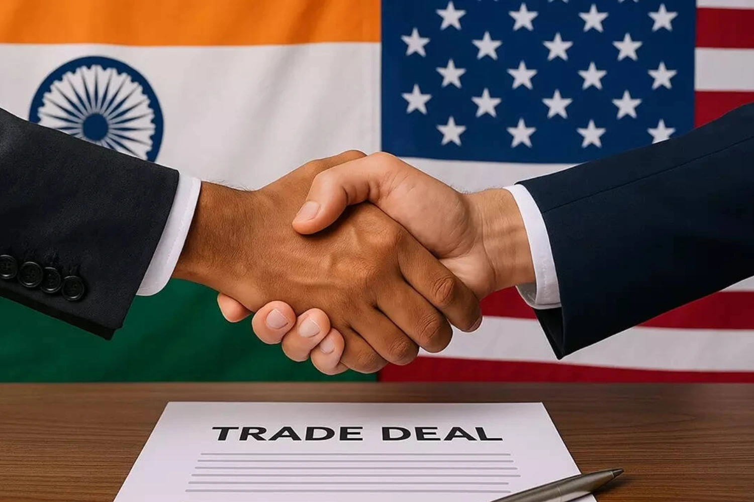
Out of nowhere, the timing pushed the map into sharper focus. Right when things seemed stuck, news dropped about a new trade deal lightening tensions between India and the US. Just then came word: American import taxes on Indian products slashed from 50 percent down to 18 percent – sudden breathing room for sellers across borders. This shift didn’t happen by accident. Officials framed it as groundwork, not the finish line. Talks will keep moving forward, they said, aiming higher than ever before.
A sign of better relations showed up quietly, through a shared glance at trade routes redrawn on paper. The head U.S. negotiator, Jamieson Greer, pointed out how border costs and hidden restrictions would fade under the new terms. Instead of old roadblocks, there’d be wider doors into one of the world’s largest shopping populations. This step fits within a longer walk toward stronger connections between two economies growing more linked. Credit went partly to India’s commerce leader, Piyush Goyal, whose steady hand shaped talks until fairness settled in the details. Symbols matter – so when maps changed hands, it felt less like paperwork, more like trust made visible.
Wrong lines drawn on foreign maps have bothered India’s external affairs office for ages – especially where Jammu and Kashmir or Arunachal Pradesh appear. Such errors stir more than mild irritation; they touch raw nerves around independence, legal unity, and safety at home. Governments, global bodies, even commercial firms found themselves facing official complaints when their charts missed the mark. So while not aimed straight at New Delhi’s concerns, the USTR illustration still lands like an overdue correction.
Right off, specialists had things to say. Former generals, global affairs watchers, journalists – they saw the image as a quiet signal favoring India over Pakistan and China. Online talk called it a boost for New Delhi, making Islamabad’s latest moves look weaker. Yet some slowed things down, saying one picture shouldn’t be blown up. After all, real policy comes from official words, deals, deeds – not posters made by commerce groups.
Still, nobody knows for sure. Could the map show America really backing India’s land stance now? Or maybe it’s just meant to ease tensions following recent trade issues. Another thought – perhaps someone in government just made a routine mistake, one that blew up only because of tense world politics nearby. All these ideas hold weight. With no clear statement from officials, people will keep arguing about what happened.
There’s no question the map handed India strong symbolic weight just when tensions were high. This move backs up New Delhi’s stance on disputed lands while pushing back against rival stories from Beijing and Islamabad. Though not an official endorsement, it shifts how things are seen – and views carry real force in global affairs.
Still, staying realistic means holding back. Maps cannot replace agreements; images won’t reset policy. Unless the U.S. clearly updates its diplomatic wording or formally backs India’s claims on PoK and Aksai Chin, this moment hints – without confirming anything. Still, in global talks, gestures tend to come before real change; quiet cues sometimes open doors ahead.
When all is said, the USTR chart sticks in memory because small things often weigh heavily on world matters. Not meant to stir tension, yet it did – raising questions over borders, partnerships, one nation’s place among powers. By choice or oversight, the image shifted how events are seen, giving India quiet recognition through lines drawn on paper. What appears silent – a layout of land and sea – can still echo loud across halls of diplomacy.